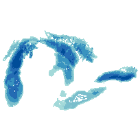
Great Lakes Bathymetry ContoursCoordinate system: 4326 - "WGS 84" Abstract:The Great Lakes Bathymetry Contours data set has been compiled as a component of a NOAA project to rescue Great Lakes lake floor geological and geophysical data and make it more accessible to the public. This bathymetry of the Great Lakes including Lake Ontario, Lake Erie, Lake Saint Clair, Lake Huron, Lake Michigan provides a detailed look at the lake floor topography and serves as a GIS base layer for many applications. Please note that the compilation of Great Lakes Bathymetry is incomplete, contours for Lake Superior are not provided in this data set, however, it is possible to create contour intervals from the original imagery consisting of elevation properties (Digital Elevation Model - DEM) collected as part of the Great Lakes Bathymetry (NOAA). This project is a cooperative effort between investigators at the NOAA National Geophysical Data Center's Marine Geology and Geophysics Division (NGDC/MGG), the NOAA Great Lakes Environmental Research Laboratory (GLERL) and the Canadian Hydrographic Service (CHS). Bathymetric data have been collected from the Great Lakes in support of nautical charting for at least 150 years by the US Army Corp. of Engineers (before 1970), the NOAA National Ocean Service (NOS) (after 1970), and the Canadian Hydrographic Service. |
Additional Documentation
-
Metadata Information
Language: eng; CANLast Update: 2014-07-02Other Maintenance Requirements:Metadata was created using metadata provided by National Oceanic and Atmospheric Administration (NOAA). doi:10.7289/V5KS6PHKMetadata Contact:Scholars Portal, Ontario Council of University Libraries Toronto Ontario, CanadaContact Instructions:gis@scholarsportal.infoMetadata Standard:North American Profile of ISO 19115 Geographic Information Metadata -
Citation Information
SeriesName: Great Lakes Bathymetry
National Oceanic and Atmospheric Administration (NOAA) Washington District of Columbia, United StatesGreat Lakes Environmental Research Lab, National Oceanic and Atmospheric Administration (NOAA) Ann Arbor Michigan, United StatesNational Ocean Service, National Oceanic and Atmospheric Administration (NOAA) Silver Spring Maryland, United StatesCanadian Hydrographic Service, Fisheries and Oceans Canada Ottawa Ontario, CanadaNational Geophysical Data Center, National Oceanic and Atmospheric Administration (NOAA) Boulder Colorado, United StatesThemes or Categories of the Resource: inlandWatersKeywords:SURFACE WATER, LAKES, WATER DEPTH, BATHYMETRY, SEAFLOOR TOPOGRAPHY, DIGITAL ELEVATION MODEL, DEM, GREAT LAKES, TOPOGRAPHY, LACUSTRINE, GEOMORPHOLOGY, STRAIGRAPHIC SEQUENCE, GEOLOGY, LAKE ERIE AND LAKE SAINT CLAIR, LAKE HURON, LAKE MICHIGAN, LAKE ONTARIO, LAKE SUPERIOR, Open DataLAKES, SURFACE WATER, WATER, Bathymetry, TOPOGRAPHY, GEOMORPHOLOGY, GEOLOGYSurface water, Eau de surface, Lakes, Lac, Topography, Topographie, Geomorphology, Géomorphologie, Geology, GéologiePlace Keywords:Continent > North America > Canada > OntarioPurpose:Scientific Research, Commercial Exploration, Fishing, Policy and Decision-making.Dataset Language:Status: completedUpdate Frequency: annuallySpatial Representation Type: vectorExtentWest Longitude: -87.992684East Longitude: -76.01000North Latitude: 46.485308South Latitude: 41.380978
Supplemental Information: -
Spatial Representation - Vector
Geometric Objects:Object Type: compositeObject Count: 115747 -
Reference System Information
-
Data Quality Information
Scope Level: datasetNational Oceanic and Atmospheric Administration (NOAA): Bathymetric data have been collected from the Great Lakes in support of nautical charting for at least 150 years by the US Army Corp. of Engineers (before 1970), the NOAA National Ocean Service (NOS)(after 1970), and the Canadian Hydrographic Service. Until now the entire array of accumulated historic soundings had never been used to systematically map the topography of the floors of Lake Erie and Lake Saint Clair. Bathymetric sounding data employed in compiling the one-meter bathymetry (National Geophysical Data Center, 1998) were collected over a 100-year period for purposes of navigation safety and nautical charting by the U. S. Army Corps of Engineers, the NOAA Coast Survey, and the Canadian Hydrographic Service. These bathymetric data, totaling several hundred thousand soundings, are separated four ways in existing archives: by whether they exist in digital form or reside only on paper sheets; and by whether they were collected by the U. S. or Canada. Final assembly of the new bathymetry has resulted from synthesis of bathymetric data from the four sources. Spacing of data control tracklines ranges from 500 to 2500 meters for the open lake and from 125 to 500 meters for nearshore areas.
Process step:National Oceanic and Atmospheric Administration (NOAA): In preparation for bathymetric contouring, digital soundings were converted to metric units and computer plotted in color according to depth range. Contours in metric units were generated directly on overlays from paper sheets and then reduced to compilation scale and patched in. Compilation sheets were scanned and vectorized; and the resulting digital bathymetric contour data constitutes the primary product. The data were hand contoured by geomorphologists to capture and portray the maximum information available, resulting in a degree of detail not attainable with machine contouring and the density of available data. Bathymetric contours were prepared by geologists using sounding data contained in the paper archives at the scale of the survey sheets (scales ranging from 1: 100,000 to 1: 10, 000); or from sounding data contained in digital data bases at standard scales of either 1: 100,000 or 1: 50,000. Details concerning the methods of compilation are given in the western Lake Erie paper (Holcombe, et al., 1997). Bathymetric contours have been spatially reconciled with the NOAA Coast Survey nominal scale 1:80,000 digital vector shoreline, which by definition coincides with the Lake Erie low water datum, the zero-depth employed for bathymetric surveys and nautical charting. -
Distribution Information
Distributor:National Geophysical Data Centre, National Oceanic and Atmospheric Administration (NOAA) Boulder Colorado, United States -
Related Links