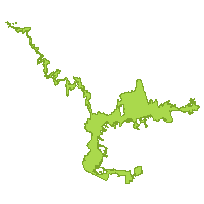
Greenbelt Outer BoundaryCoordinate system: 4269 - "NAD83" Abstract:This data set is a polygon coverage that can be used to identify the outer boundary of the Greenbelt Area, as defined by Ontario Regulation 59/05 as amended, which includes lands within the Niagara Escarpment Plan Area, the Oak Ridges Moraine Area, and lands designated as Protected Countryside, and Urban River Valley, by this Plan. |
Additional Documentation
-
Metadata Information
Language: eng; CANLast Update: 2014-06-11Other Maintenance Requirements:f2a61443-42d7-4930-be52-c0ba0672987fMetadata Contact:Scholars Portal, Ontario Council of University Libraries Toronto Ontario, CanadaContact Instructions:gis@scholarsportal.infoMetadata Standard:North American Profile of ISO19115:2003 - Geographic Information -
Citation Information
Ontario Ministry of Municipal Affairs and Housing Toronto Ontario, CanadaThemes or Categories of the Resource: boundariesKeywords:GREENBELT OUTER BOUNDARY, PROTECTED COUNTRYSIDE, NIAGARA ESCARPMENT PLAN, OAK RIDGES MORAINE, URBAN RIVER VALLEY, PLANNING, DEVELOPMENT, LAND USE, ENVIRONMENT, LAND MANAGEMENT, GREENBELT, GREENBELT BOUNDARY, LAND USE PLANNINGPLANNING, DEVELOPMENT, LAND USE, ENVIRONMENT, ENVIRONMENTAL PROTECTION, LAND USE PLANNINGPlanning, Planification, Development, Développement, Land management, Gestion des terres, Environment, Environnement, Environmental protection, Protection de l'environnementPlace Keywords:Continent > North America > Canada > OntarioPurpose:To identify the Greenbelt Area as defined by Ontario Regulation 59/05, as amended.Dataset Language:Status: completedUpdate Frequency: asNeededSpatial Representation Type: vectorProcessing Environment:Data require mapping/CAD software to view. Data created in ESRI shape files.ExtentWest Longitude: -81.776235East Longitude: -77.909897North Latitude: 45.327937South Latitude: 43.014743
Supplemental Information: -
Spatial Representation - Vector
Geometric Objects:Object Type: compositeObject Count: 1 -
Reference System Information
-
Data Quality Information
Scope Level: dataset
LIO Municipal boundaries 2005: Some of the line segments came from LIO municipal boundaries, 2005. -
Distribution Information
Distributor:Ontario Geospatial Data Exchange, Ministry of Natural Resources (OMNR) Peterborough Ontario, Canada